Navigation:
VariCAD Viewer 2025 3.01 freeware
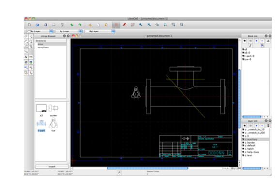
... VariCAD, this software supports a wide range of file formats, ensuring compatibility with various CAD applications. Its user-friendly interface allows for easy navigation and manipulation of designs, while features like measurement tools and layer management enhance productivity. Ideal for quick reviews and presentations, VariCAD Vi ... ...
| Author | VariCAD |
| Released | 2025-07-31 |
| Filesize | 3.70 MB |
| Downloads | 2113 |
| OS | Windows 11, Windows 10 64 bit, Windows 8 64 bit, Windows 7 64 bit |
| Installation | Instal And Uninstall |
| Keywords | VariCAD Viewer, CAD Viewer, CAD Explorer, CAD, Converter, Convert, DWG |
| Users' rating (56 rating) |
VariCAD Viewer Free Download - we do not host any VariCAD Viewer torrent files or links of VariCAD Viewer on rapidshare.com, depositfiles.com, megaupload.com etc. All VariCAD Viewer download links are direct VariCAD Viewer download from publisher site or their selected mirrors.
| 2025 3.01 | Jul 31, 2025 | New Release | The Viewer contains significant changes – a possibility to manage sections as a full version (define, edit or delete sections), in 2D you can change line style or width (in addition to existing color changes) and generally, you can right-click an object and select available functions, or right-click an empty location and also select available functions. |
| 2025 1.06 | Mar 4, 2025 | New Release | This new version contains an improvement in 3D modeling kernel, changes in creation of helical surfaces, support of real 3D threads, updates in smart dimensioning and in creation of 2D from 3D. Solids created as helices (by rotation and simultaneous extrusion) are defined by a contour in a sketching plane. The new version has a more intuitive approach to helix definition, to sketching of contours creating a helix. Similarly, as in case of extrusion, you can change helix height and/or number of coils also by cursor movement. Using features creating threaded cylinders, threaded holes or cutting threads on existing cylindrical surfaces, you can select a new option – to create a real 3D thread. The thread profile complies exactly to ISO metric threads, or to ANSI threads in case of working in inches. The threaded surface is created schematically by default. You can change the existing schematic thread to real 3D thread and vice versa, or to create a 3D thread immediately. Real 3D threads are suitable for 3D printing of mechanical parts. Another improvement is in the creation of 2D from 3D views. If you have some 3D objects displayed in original locations and some are copied into an exploded view, 2D is now created completely in one step, including both standard and exploded view. Using 2D smart dimensioning, cylindrical surfaces are now recognized always exactly. |
| 2025 1.05 | Feb 20, 2025 | New Release | This new version contains an improvement in 3D modeling kernel, changes in creation of helical surfaces, support of real 3D threads, updates in smart dimensioning and in creation of 2D from 3D. Solids created as helices (by rotation and simultaneous extrusion) are defined by a contour in a sketching plane. The new version has a more intuitive approach to helix definition, to sketching of contours creating a helix. Similarly, as in case of extrusion, you can change helix height and/or number of coils also by cursor movement. Using features creating threaded cylinders, threaded holes or cutting threads on existing cylindrical surfaces, you can select a new option – to create a real 3D thread. The thread profile complies exactly to ISO metric threads, or to ANSI threads in case of working in inches. The threaded surface is created schematically by default. You can change the existing schematic thread to real 3D thread and vice versa, or to create a 3D thread immediately. Real 3D threads are suitable for 3D printing of mechanical parts. Another improvement is in the creation of 2D from 3D views. If you have some 3D objects displayed in original locations and some are copied into an exploded view, 2D is now created completely in one step, including both standard and exploded view. Using 2D smart dimensioning, cylindrical surfaces are now recognized always exactly. |