KiCad for Mac OS X 8.0.2 freeware

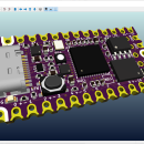
KiCad includes a 3D viewer which you can use to inspect your design in an interactive canvas. You can rotate and pan around to inspect details that are difficult to inspect on a 2D view. Multiple rendering options allow you to modify the aesthetic appearance of the board or to hide and show features for easier inspection. ...

Author Jean Pierre Charras
Released 2024-04-28
Filesize 1700.00 MB
Downloads 198
OS Mac OS X
Installation Instal And Uninstall
Keywords Design PCB, Create Diagram, Build Prototype, PCB, Circuit, Diagram, Electronics, Mac OS X
Users' rating
(12 rating)
KiCad for Mac OS XCADMac OS X
KiCad for Mac OS X - save display Freeware Download Notice

KiCad for Mac OS X Free Download - we do not host any KiCad for Mac OS X torrent files or links of KiCad for Mac OS X on rapidshare.com, depositfiles.com, megaupload.com etc. All KiCad for Mac OS X download links are direct KiCad for Mac OS X download from publisher site or their selected mirrors.

KiCad for Mac OS X freeware - The Latest User Reviews
KiCad for Mac OS X freeware - The Latest Versions History
8.0.2 Apr 28, 2024 New Release
7.0.10 Jan 3, 2024 New Release
7.0.9 Nov 9, 2023 New Release Fix orphaned lock files.
Set focus back to the main window after dialog is dismissed.
Draw zero sized rectangles on OpenGL canvas.
Fix zero sized or too thick rectangles when plotting to PDF.
Prevent rectangles from always being filled when plotting to HPGL.
Fix random lines connecting to circles when plotting in HPGL.
Improve bitmap caching performance.
Don’t show integer overflow errors in release builds.

Most popular CAD freeware downloads

QGIS for Linux

3.36.1 freeware download

... geotiff). QGIS supports plugins to do things like display tracks from your GPS. QGIS aims to ... layers · Map composer · Identify features · Display attribute table · Select features · Label features ...

QtGrace

0.2.6 freeware download

... specially designed to offer users a program to display or plot data, analyze data and prepare it ... ...) · Add labels, decorations and comments · Save, print, export your results (for example for scientific ...

QtGrace for Mac OS X

0.2.6 freeware download

... specially designed to offer users a program to display or plot data, analyze data and prepare it ... ...) · Add labels, decorations and comments · Save, print, export your results (for example for scientific ...

QtGrace for Linux

0.2.6 freeware download

... specially designed to offer users a program to display or plot data, analyze data and prepare it ... ...) · Add labels, decorations and comments · Save, print, export your results (for example for scientific ...

Gabedit

2.5.1 freeware download

... OpenMopac, Orca, PCGamess and Q-Chem It can display a variety of calculation results including support for ... OpenMopac, Orca, PCGamess and Q-Chem. Gabedit can graphically display a variety of Gamess-US, Gaussian, Molcas, Molpro, MPQC, ...

Gabedit for Linux

2.5.1 freeware download

... OpenMopac, Orca, PCGamess and Q-Chem It can display a variety of calculation results including support for ... OpenMopac, Orca, PCGamess and Q-Chem. Gabedit can graphically display a variety of Gamess-US, Gaussian, Molcas, Molpro, MPQC, ...

SeiSee

2.22.6 freeware download

... (.bmp) and PostScript formats. - SEG-Y trace headers display (formats Integer*1,*2,*4, IEEE Float*4,*8, IBM Float*4 are supported) ... header value - selection of traces to be displayed by trace index or header value and by ...

CARIS Easy View

4.2.13 freeware download

... which they are drawn and adjust each layer's display parameters. Users can also make selections and query ... multiple types of files, as various GIS applications save maps and models to a wide array of ...

NetLogo

6.0.4 freeware download

... be exported locally, turned into a movie or saved as applets and used in the educational process, ... controlling agents Export and import functions (export data, save and restore state of model, make a movie) ...

QGIS

3.36.1 freeware download

... geotiff). QGIS supports plugins to do things like display tracks from your GPS. QGIS aims to ... layers · Map composer · Identify features · Display attribute table · Select features · Label features ...