SeiSee 2.22.6 freeware

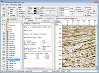
... the users that need to view and to analyze the data about earthquakes stored in SEG-Y files. The program can also view the content of CWP, CGG and CST files in order to examine the data.You can use the program to open the single shot files and to view the headers and the seismic data. The file processing can be adjusted by changing the gain control and the filter spectrum. ...

Author Sergey I. Pavlukhin
Released 2015-04-17
Filesize 6.30 MB
Downloads 796
OS Windows XP, Windows Vista, Windows Vista x64, Windows 7, Windows 7 x64, Windows 8, Windows 8 x64, Windows 10, Windows 10 x64
Installation Instal And Uninstall
Keywords seismic data viewer, analyze earthquake data, view SEG-Y, sesmic, view, viewer
Users' rating
(33 rating)
SeiSeeCADWindows XP, Windows Vista, Windows Vista x64, Windows 7, Windows 7 x64, Windows 8, Windows 8 x64, Windows 10, Windows 10 x64
SeiSee - analyze image Freeware Download Notice

SeiSee Free Download - we do not host any SeiSee torrent files or links of SeiSee on rapidshare.com, depositfiles.com, megaupload.com etc. All SeiSee download links are direct SeiSee download from publisher site or their selected mirrors.

SeiSee freeware - The Latest User Reviews
SeiSee freeware - The Latest Versions History
2.22.6 Apr 17, 2015 New Release Some bugs fixed
2.22.5 Apr 17, 2015 New Release Some bugs fixed
2.22.2 Nov 7, 2013 New Release Some bugs fixed

Most popular CAD freeware downloads

Gwyddion for Linux

2.66 freeware download

... generally used for any other height field and image analysis, for instance for analysis of profilometry data ... axes scale callibration · merging and immersion of images · tip modelling, blind estimation, dilation and erosion ...

Energy2D for Mac OS X

2.6 freeware download

... comparison of the results of Energy2D simulations with images from infrared (IR) thermography for a simple house. ... by Energy2D closely match those from an infrared imager. The second set of image shows a similarity ...

Portable MicroDicom x64

2024.2 freeware download

... application for primary processing and preservation of medical images in DICOM format. It is equipped with most common tools for manipulation of DICOM images and it has an intuitive user interface. ...

TNTmips for Mac OS X

20240111 freeware download

... with virtually any type of geospatial data including imagery, terrain surfaces, and map data with associated database ... without importing. Overlay your geodata on Bing Maps imagery and maps or on geodata layers published on ...

MicroDicom x64

2024.2 freeware download

... application for primary processing and preservation of medical images in DICOM format. It is equipped with most common tools for manipulation of DICOM images and it has an intuitive user interface. ...

MITO

2.0 freeware download

... makes it possible to fetch radiological information and images stored in a PACS according to the standard ... functionalities such as 2D-3D visualization (VR, SR, MIP), image segmentation and fusion, ROI. Moreover, MITO provides interaction ...

Energy2D

2.6 freeware download

... comparison of the results of Energy2D simulations with images from infrared (IR) thermography for a simple house. ... by Energy2D closely match those from an infrared imager. The second set of image shows a similarity ...

QFitsView

8.6 freeware download

... core, DS9 excels in displaying and analyzing astronomical images, supporting a wide array of file formats including ... noteworthy, ensuring that users can work with high-resolution images without performance bottlenecks. One of DS9's standout ...

Balony October for Mac OS X

1.4.5 freeware download

... use application, specially designed to offer you an image analysis and data inspection for agar plates generated ... were looking for a tool to help you analyze agar plates give Balony a try and check ...

TNTmips

20240404 freeware download

... with virtually any type of geospatial data including imagery, terrain surfaces, and map data with associated database ... without importing. Overlay your geodata on Bing Maps imagery and maps or on geodata layers published on ...