GOM Inspect 7.5 SR1 freeware

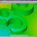
GOM Inspect is a free 3D inspection and mesh processing software for dimensional analysis of 3D point clouds and viewer for ATOS and GOM Inspect Professional data sets.GOM Inspect automatically converts point cloud data into high quality 3D mesh data and offers extensive post-processing functionalities.GOM Inspect is available for customers and colleagues to review the measurement results and to perform further analysis. ...

Author GOM
Released 2012-10-25
Filesize 417.66 MB
Downloads 577
OS Windows XP, Windows Vista, Windows 7
Installation Instal And Uninstall
Keywords CAD, mesh, inspection, analyze, data
Users' rating
(17 rating)
GOM InspectCADWindows XP, Windows Vista, Windows 7
GOM Inspect - export file Freeware Download Notice

GOM Inspect Free Download - we do not host any GOM Inspect torrent files or links of GOM Inspect on rapidshare.com, depositfiles.com, megaupload.com etc. All GOM Inspect download links are direct GOM Inspect download from publisher site or their selected mirrors.

GOM Inspect freeware - The Latest User Reviews
GOM Inspect freeware - The Latest Versions History
7.5 SR1 Oct 25, 2012 New Release

Most popular CAD freeware downloads

QGIS for Mac

3.36.1 freeware download

... formats support by the OGR library · MapInfo files · GRASS integration, including view, edit, and analysis ... raster symbology (grayscale, pseudocolor and multiband RGB) · Export to Mapserver map file · Digitizing support · ...

QFitsView

8.6 freeware download

... analyzing astronomical images, supporting a wide array of file formats including FITS, which is the standard in ... for remote data access and the ability to export images and analysis results in various formats. This ...

QGIS

3.36.1 freeware download

... formats support by the OGR library · MapInfo files · GRASS integration, including view, edit, and analysis ... raster symbology (grayscale, pseudocolor and multiband RGB) · Export to Mapserver map file · Digitizing support · ...

QGIS for Linux

3.36.1 freeware download

... formats support by the OGR library · MapInfo files · GRASS integration, including view, edit, and analysis ... raster symbology (grayscale, pseudocolor and multiband RGB) · Export to Mapserver map file · Digitizing support · ...

TNTmips

20240404 freeware download

... coordinates from GPS devices ... Import and export an unsurpassed number of raster, geometric, and database file formats; convert between data types; and link to ...

KiCad for Mac OS X

8.0.2 freeware download

... circuits. KiCad allows you to upload NET files and view the selected footprint, record macros, assign hotkeys, and save the generated projects to ZIP file format. Other important options worth mentioning enable ...

FilterPro Desktop

3.1.0.23446 freeware download

... variations; scale passive component values; and view and export filter performance data to Excel. FilterPro ... filters now accounts for passband ripple Supports design file migration from FilterPro v2 so that designs created ...

GpsTools Studio

2.3.1 build 227 freeware download

... to import a map from a popular image file and to export it to a compatible format. The ...

DSI Studio

.59 freeware download

... of passing and/or regions of avoidace. · Supported file format for input ROI: text file, Analyze, NIFTI · Supported file format for output tracts: text file, TrackVis .trk ...

Spirograph

1.0.2.1 freeware download

... toy) · See image creation as animation · Export the created patterns to image file · Save you work for later use · ...