TatukGIS Viewer 5.71.0 freeware

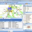
The TatukGIS Editor is a programmable, general purpose desktop GIS mapping and data editing application featuring support for dozens of vector, image, grid, and SQL database formats, on-the-fly map reprojection with nearly 3,000 pre-defined coordinate systems, compatibility with leading database engines, GPS connectivity… ...

Author TatukGIS Sp. z o. o.
Released 2024-04-04
Filesize 120.00 MB
Downloads 525
OS Windows XP, Windows Vista, Windows Vista x64, Windows 7, Windows 7 x64, Windows 8, Windows 8 x64, Windows 10, Windows 10 x64, Windows 11
Installation Instal And Uninstall
Keywords raster image Viewer, GIS editor, GIS map, viewer, graphic, view
Users' rating
(27 rating)
TatukGIS ViewerOtherWindows XP, Windows Vista, Windows Vista x64, Windows 7, Windows 7 x64, Windows 8, Windows 8 x64, Windows 10, Windows 10 x64, Windows 11
TatukGIS Viewer - google Freeware Download Notice

TatukGIS Viewer Free Download - we do not host any TatukGIS Viewer torrent files or links of TatukGIS Viewer on rapidshare.com, depositfiles.com, megaupload.com etc. All TatukGIS Viewer download links are direct TatukGIS Viewer download from publisher site or their selected mirrors.

TatukGIS Viewer freeware - The Latest User Reviews
TatukGIS Viewer freeware - The Latest Versions History
5.71.0 Apr 4, 2024 New Release
5.70.0 Feb 24, 2024 New Release
5.69.0 Jan 29, 2024 New Release

Most popular Other freeware downloads

TatukGIS Viewer

5.71.0 freeware download

... of example scripts are provided, e.g., to perform Google or Bing maps integration, GPS tracking on a projected map, batch (command line) conversions between coordinate ...

GeoSetter

3.5.3 freeware download

... geo coordinates, image directions and tracks on embedded Google Maps map (requires internet connection) Setting geo data by using embedded Google Maps map (requires internet connection) or by entering ...

ATOM GPS

1.0.5 freeware download

... easy browsing, and also upload your pictures to Google Earth, Google maps, Panoramio, LOCR, Flickr. - Supports many GPS ... and travel itineraries by geotagging your photos. - Google Earth export - Languages: English ...

Latipics

1.2 freeware download

If you’re already using the Google Latitude service on your mobile phone or you ... you will be able to log into your Google account (without sharing your password with Latipics), select ...

ExifTool GUI for Windows

5.16.0.0 freeware download

ExifTool GUI is a (free) Graphical User Interface for an already existing EXIF editor called ExifTool, developed by Phil Harvey, a full-featured - command-line - utility. ...

GPX Editor

1.7.14 B1740 freeware download

... easily edit fields, as well as switch to Google Maps viewing mode. Data is importable from NMEA, NGT and KML formats, and exportable to KML, ...

Ruckzuck Wasserzeichen

4.0.0.1 freeware download

Super-fast watermark, quickly add a few clicks a watermark to your images .sign images. Easy and fast. The image size can be adjusted as desired. The ...

Google Photos

1.1.4.11 freeware download

Google Photos is a photo sharing and storage service developed by Google. Google Photos gives users free, unlimited storage for photos ... from three major categories: People, Places, and Things. Google Photos recognizes faces, grouping similar ones together; geographic ...

Google Photos for Android

2.12.0 freeware download

Google Photos is a photo sharing and storage service developed by Google. Google Photos gives users free, unlimited storage for photos ... from three major categories: People, Places, and Things. Google Photos recognizes faces, grouping similar ones together; geographic ...

Google Photos for iOS

2.12.0 freeware download

Google Photos is a photo sharing and storage service developed by Google. Google Photos gives users free, unlimited storage for photos ... from three major categories: People, Places, and Things. Google Photos recognizes faces, grouping similar ones together; geographic ...