KaPiGraf 3.5 freeware

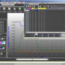
You only have to open the data set file and at the push of a button, the graph will be created. This graph can be used in many ways: moving, zooming, changing parameters, exporting into MS Excel, printing, saving, transfering units and many others. The program does not impose the 32000 data rows limit of Excel. ...

Author KaPiZone
Released 2021-08-02
Filesize 1.40 MB
Downloads 971
OS Windows 2000, Windows 2003, Windows XP, Windows Vista, Windows Vista x64, Windows 7, Windows 7 x64, Windows 8, Windows 8 x64, Windows 10, Windows 10 x64
Installation Instal And Uninstall
Keywords create graph, data plotter, graph generator, plotter, plot, graph
Users' rating
(14 rating)
KaPiGrafCADWindows 2000, Windows 2003, Windows XP, Windows Vista, Windows Vista x64, Windows 7, Windows 7 x64, Windows 8, Windows 8 x64, Windows 10, Windows 10 x64
Our rating 5 freeware award
KaPiGraf - help file Freeware Download Notice

KaPiGraf Free Download - we do not host any KaPiGraf torrent files or links of KaPiGraf on rapidshare.com, depositfiles.com, megaupload.com etc. All KaPiGraf download links are direct KaPiGraf download from publisher site or their selected mirrors.

KaPiGraf freeware - The Latest User Reviews
KaPiGraf freeware - The Latest Versions History
3.5 Aug 2, 2021 New Release
2.9 Apr 25, 2016 New Release All function available for everybody
Preview/Edit added filter the graph view
Add moving for X axis in Live Graph
Add moving average in mathematical module
2.5 Apr 25, 2016 New Release menu Display (F3) - added user color curves
added choice - chart in chart (tab Graph - right click on minor axis) show curve in a new chart
improved work with EXCEL file
math. module - filtering all curves

Most popular CAD freeware downloads

FilterPro Desktop

3.1.0.23446 freeware download

... filters now accounts for passband ripple Supports design file migration from FilterPro v2 so that designs created ... reports containing all design data and schematics to help speed time to market. Supports Bessell, Butterworth, Chebychev, ...

OpenDCL Studio

9.1.5.2 freeware download

OpenDCL is a handy, easy-to-use and accessible insturment that is specially designed for AutoLISP programmers that want to replace AutoCAD's limited DCL. They can replace ...

Doodles 3D

0.76 freeware download

Doodles 3D is a handy application designed to help you create 3D models by adding points and ... You can save the points to a text file that can be easily modified with a basic ...

Engauge Digitizer for Linux

12.0 freeware download

... This open source, digitizing software converts an image file showing a graph or map, into numbers. The image file can come from a scanner, digital camera or ...

Geogiga Front End

9.0 freeware download

... data Resample and cut seismic data Integrate multiple files Support SEG-2, SEG-Y, SEG-D, ASCII, and other data formats Convert other data formats to SEG-2, SEG-Y, ...

SCaVis

2.3 freeware download

... AIDA data formats. Finally, it uses several platform-neutral file formats, including the compressed Google's Protocol Buffers format. Professional output graphics for data and function visualization. ...

5 freeware award

Portable MicroDicom

2024.2 freeware download

... *.bmp, *.gif, etc) Open and save DICOM directory files Display of patient list from DICOMDIR Display images ... images to the most common picture formats, movie file format(.avi) and clipboard Brightness/contrast control Zooming and panning ...

TinyCAD

3.00.04 freeware download

TinyCAD is a program to help you draw circuit diagrams. It comes complete with ... bitmap. TinyCAD supports outputing ciruits diagrams as PNG files. If you are not familar with PNG files, ...

SeqView

1.3 freeware download

... is a small, simple application specially designed to help you view and analyze sequence files with just a few click. You can ... So, if you needed a bioinformatics tool to help you with sequence analysis, give this tool a ...

Mobile Atlas Creator for Mac OS X

2.2.1 freeware download

... as one large PNG image with calibration MAP file for OziExplorer. As source for an offline atlas ... Trail Explorer (J2ME) - single tiles and MTECache file NaviComputer (Windows Mobile) nfComPass (WinCE, WinMobile, WinXP) OruxMaps ...