Virtual Terrain Project for Windows 1.1 110804 freeware

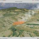
The goal of VTP is to foster the creation of tools for easily constructing any part of the real world in interactive, 3D digital form.

This goal will require a synergetic convergence of the fields of CAD, GIS, visual simulation, surveying and remote sensing. VTP gathers information and tracks progress in areas such as procedural scene construction, feature extraction, and rendering algorithms. ...

Author Ben Discoe
Released 2011-09-08
Filesize 1.00 MB
Downloads 473
OS Windows 2000, Windows 2003, Windows XP, Windows Vista
Installation Instal And Uninstall
Keywords libraries, demos, data, open source, VirtualTerrain Project, CAD, GIS, VTP
Users' rating
(18 rating)
Virtual Terrain Project for WindowsCADWindows 2000, Windows 2003, Windows XP, Windows Vista
Virtual Terrain Project for Windows - linux software Freeware Download Notice

Virtual Terrain Project for Windows Free Download - we do not host any Virtual Terrain Project for Windows torrent files or links of Virtual Terrain Project for Windows on rapidshare.com, depositfiles.com, megaupload.com etc. All Virtual Terrain Project for Windows download links are direct Virtual Terrain Project for Windows download from publisher site or their selected mirrors.

Virtual Terrain Project for Windows freeware - The Latest User Reviews
Virtual Terrain Project for Windows freeware - The Latest Versions History
1.1 110804 Sep 8, 2011 New Release Enviro:
Exposed support for more stereo modes: Horizontal and Vertical split.
Options to enable joystick and spacenavigator, rather than just always using them if present.
Smooth continuous update when making buildings.
Option to constrain building point to right angles. Deter user from making bad points.
Made support for Collada (.dae) more explicit in the UI.
Display the version number in the startup dialog.
Added 'every N meters' option to Contour dialog, making it significantly more useful.
Changed 'Move' mode to use Alt modifier key for up/down, to be consistent.
Fixed issues with: support for elevation grids with non-unit vertical scale; removing layers from a terrain; saving snapshot and high-resolution snapshot; buildings with a Geographic CRS; draping of 2D polylines on terrain with vertical exaggeration.

VTBuilder:
Raw layers: Draw polygon holes as dotted lines to tell them from outer edges.

Most popular CAD freeware downloads

EQAlign

2.3.7 freeware download

EQAlign born as a software that assists to align a German Equatorial Mount ... polar align feature, EQAlign is a full featured software that: Can be used to measure and analyse ...

Rocket Propulsion Analysis Lite x64

1.2.0 freeware download

... With release of the RPA Lite Edition, software.lpre.de offers the modern rocket engines analysis tool and ... well as for AppleĀ® Mac OS X and Linux Embedded species database editor ...

QtGrace for Mac OS X

0.2.6 freeware download

... analyze data and prepare it for printing. This software is special because it combines the convenience of a graphical user interface with the power of ...

QtGrace for Linux

0.2.6 freeware download

... analyze data and prepare it for printing. This software is special because it combines the convenience of a graphical user interface with the power of ...

FreeDiams for Mac OS X

1.0.0 freeware download

... a standalone application. FreeDiams is a multi-platform (MacOS, Linux, FreeBSD, Windows), free and open source released under ... Free Drugs InterActions Manager and preScriptor. FreeDiams software is stable and finalized. It can be used ...

Kst for Linux

2.0.7 freeware download

Kst is the fastest real-time large-dataset viewing and plotting tool available (you may be interested in some benchmarks) and has built-in data analysis functionality. Kst is ...

FreeMedForms for Mac OS X

1.0.0 freeware download

FreeMedForms is free and open source software, available for all current platforms (Linux, Mac OS X, Windows and FreeBSD). It is powerful and fully configurable. ...

Gabedit for Linux

2.5.1 freeware download

Gabedit is a graphical user interface to computational chemistry packages like Gamess-US, Gaussian, Molcas, Molpro, MPQC, OpenMopac, Orca, PCGamess and Q-Chem It can display a ...

QGIS for Linux

3.36.1 freeware download

... proud to be itself Free and Open Source Software (FOSS). QGIS supports vector, raster, and database formats and lets you browse and create map ...

Sailcut CAD

1.3.5 freeware download

Sailcut CAD is a sail design and plotting software which allows you to design and visualise your own sail and compute the accurate development of ...