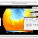
Panoply for Mac 5.4.3 freeware

... user to plot raster image. Depending on the data, it can draw global longitude-latitude images or pole-to-pole ... plots geo-gridded arrays from netCDF, HDF and GRIB datasets. The utility can also combine two arrays and can project the analysis using more than 100 maps. ...

Author Robert B. Schmunk
Released 2024-06-24
Filesize 36.40 MB
Downloads 887
OS Mac OS X
Installation Instal And Uninstall
Keywords plot raster image, longitude image, pole-to-pole image, raster image, rasterize, raster
Users' rating
(38 rating)
Panoply for MacCADMac OS X
Panoply for Mac - data on map Freeware Download Notice

Panoply for Mac Free Download - we do not host any Panoply for Mac torrent files or links of Panoply for Mac on rapidshare.com, depositfiles.com, megaupload.com etc. All Panoply for Mac download links are direct Panoply for Mac download from publisher site or their selected mirrors.

Panoply for Mac freeware - The Latest User Reviews
Panoply for Mac freeware - The Latest Versions History
5.4.3 Jun 24, 2024 New Release
5.4.1 Jun 1, 2024 New Release
5.4.0 May 11, 2024 New Release

Most popular CAD freeware downloads

MagicPlot Student

2.9.3 freeware download

... is a handy tool for scientific and engineer data processing, plotting and nonlinear fitting. MagicPlot is powerful ... export and copying * Automatic formula recalculation on data change * English ligatures support in labels ...

MagicPlot Student for Mac OS X

2.9.3 freeware download

... is a handy tool for scientific and engineer data processing, plotting and nonlinear fitting. MagicPlot is powerful ... export and copying * Automatic formula recalculation on data change * English ligatures support in labels ...

MagicPlot Student for Linux

2.9.3 freeware download

... is a handy tool for scientific and engineer data processing, plotting and nonlinear fitting. MagicPlot is powerful ... export and copying * Automatic formula recalculation on data change * English ligatures support in labels ...

CueMol

2.2.3.442 freeware download

... (CCP4, CNS , and BRIX format), MSMS surface data, and GRASP electrostatic potential map. ...

DX Central

2.20 freeware download

... different views of the sun · Doppler MDI map of the sun's far side · D-Region X-Ray absorption map from NOAA SWPC · Updates automatically every 10 ...

DX Central for Linux

2.20 freeware download

... different views of the sun · Doppler MDI map of the sun's far side · D-Region X-Ray absorption map from NOAA SWPC · Updates automatically every 10 ...

SoundStepper

5.4.1.304 freeware download

... telescope control, such as for example a sky map, autoguiding, or capture images from a webcam or ... to use the computer's sound hardware, which has data buffers and processing itself, to control step motors ...

Thuban for Windows

1.2.2 freeware download

Thuban is an interactive geographic data viewer (GIS viewer) which features methods to visualize, ... geographic information. Thuban is an Interactive Geographic Data Viewer with the following features: # Vector ...

Thuban for Mac OS X

1.0.1-3 freeware download

Thuban is an interactive geographic data viewer (GIS viewer) which features methods to visualize, ... geographic information. Thuban is an Interactive Geographic Data Viewer with the following features: # Vector ...

Thuban for Linux

1.2.2 freeware download

Thuban is an interactive geographic data viewer (GIS viewer) which features methods to visualize, ... geographic information. Thuban is an Interactive Geographic Data Viewer with the following features: # Vector ...