BimRoad Plus freeware

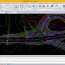
Parametric road design. The world's first software for automatic interchange design. Three-dimensional alignment design. Real-time interchange redesign considering design standards by changing the main alignment. All type of interchange design using user defined connection road. Automatic connection road plan by editing nose point. Automatic correction of road plan design element using parametric method. ...

Author HaneeSoft
Released 2015-01-01
Filesize 232.65 MB
Downloads 294
OS Win2000, Windows XP, Windows 7 x32, Windows 7 x64, Windows 8, Windows 10, WinServer, WinOther, Windows Vista, Windows Vista x64
Installation Install and Uninstall
Keywords Road design, Interchange design, Alignment, Earthwork
Users' rating
(16 rating)
BimRoadCADWin2000, Windows XP, Windows 7 x32, Windows 7 x64, Windows 8, Windows 10, WinServer, WinOther, Windows Vista, Windows Vista x64
BimRoad - data Freeware Download Notice

BimRoad Free Download - we do not host any BimRoad torrent files or links of BimRoad on rapidshare.com, depositfiles.com, megaupload.com etc. All BimRoad download links are direct BimRoad download from publisher site or their selected mirrors.

BimRoad freeware - The Latest User Reviews
BimRoad freeware - The Latest Versions History
Plus Jan 1, 2015 New Release Road design.
Topography creation.
Plane design.
Profile Design.
Interchange automatic design.
Cross section design.
Earthwork.
Hydraulics.
Report / Drawing.

Most popular CAD freeware downloads

Panoply for Mac

5.4.3 freeware download

... plots geo-gridded arrays from netCDF, HDF and GRIB datasets. Panoply is designed to help you view and process the data included in netCDF, HDF, GRIB, and other types ...

FilterPro Desktop

3.1.0.23446 freeware download

... component values; and view and export filter performance data to Excel. FilterPro active filter design ... and print professional design reports containing all design data and schematics to help speed time to market. ...

Kst for Linux

2.0.7 freeware download

... be interested in some benchmarks) and has built-in data analysis functionality. Kst is very user-friendly (both the ... FEATURES: · Robust plotting of live "streaming" data. · Powerful keyboard and mouse plot manipulation. · ...

Aqsis Renderer for Mac OS X

1.8.2 freeware download

... level surface descriptions to render from, reducing the data passed to the renderer, while ensuring a perfectly ... user choice, this results in large amounts of data being sent to the renderer in order to ...

QtGrace

0.2.6 freeware download

... offer users a program to display or plot data, analyze data and prepare it for printing. This software is ... automated tasks. FEATURES: · Import numerical data (like scientific measurements, statistics) · Organize and plot ...

SCaVis

2.3 freeware download

SCaVis is an environment for scientific computation, data analysis and data visualization designed for scientists, engineers and students. The ... used everywhere where an analysis of large numerical data volumes, data mining, statistical analysis and mathematics are ...

5 freeware award

MagicPlot Student for Mac OS X

2.9.3 freeware download

... is a handy tool for scientific and engineer data processing, plotting and nonlinear fitting. MagicPlot is powerful ... export and copying * Automatic formula recalculation on data change * English ligatures support in labels ...

TARQUIN for Linux

4.3.6 freeware download

... the quantities of molecules present in NMR spectroscopic data. The intended purpose of TARQUIN is to aid the characterisation of pathologies, in particular brain tumours, ...

Geogiga Front End

9.0 freeware download

... and preprocess single shot record. You can convert data formats, analyze amplitude decay, correct trigger delay, assign ... are available, such as the geometry assignment, seismic data resampling, and trigger delay correction. Main Features: ...

QGIS for Mac

3.36.1 freeware download

... Software (FOSS). QGIS supports vector, raster, and database formats and lets you browse and create map data on your computer. QGIS supports many common ...