GetNexrad 4.4.2 freeware

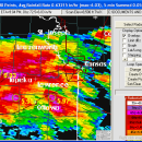
GetNexrad 3.5.2 is a tool used to view real-time area radar rainfall loops and to generate the basin point file (NexradPointESX10210.txt) used by GetRealtime.exe for computing the basin area average rainfall time series in real time. ...

Author Carson
Released 2023-08-08
Filesize 10.00 MB
Downloads 586
OS Windows XP, Windows Vista, Windows Vista x64, Windows 7, Windows 7 x64, Windows 8, Windows 8 x64, Windows 10, Windows 10 x64, Windows 11
Installation Instal And Uninstall
Keywords extract rainfall amount, DBZ analysis, view radar rainfall, view, extract, rainfall
Users' rating
(15 rating)
GetNexradCADWindows XP, Windows Vista, Windows Vista x64, Windows 7, Windows 7 x64, Windows 8, Windows 8 x64, Windows 10, Windows 10 x64, Windows 11
GetNexrad - map Freeware Download Notice

GetNexrad Free Download - we do not host any GetNexrad torrent files or links of GetNexrad on rapidshare.com, depositfiles.com, megaupload.com etc. All GetNexrad download links are direct GetNexrad download from publisher site or their selected mirrors.

GetNexrad freeware - The Latest User Reviews
GetNexrad freeware - The Latest Versions History
4.4.2 Aug 8, 2023 New Release
4.3.3 Feb 19, 2019 New Release
4.1.5 Mar 8, 2017 New Release

Most popular CAD freeware downloads

Panoply for Mac

5.4.3 freeware download

... one plot by differencing, summing or averaging. Create map plots of trajectory data based on the CF ... Plot lon-lat data on a global or regional map using any of over 200 map projections or ...

TNTatlas

2024 B20240606 freeware download

... — from a single geodata file to complex map layouts prepared using TNTmips. TNTatlas lets you display ... have to rapidly assemble and distribute existing electronic map and database materials for those working in natural ...

QGIS for Linux

3.36.1 freeware download

... database formats and lets you browse and create map data on your computer. QGIS supports many ... On the fly projection of vector layers · Map composer · Identify features · Display attribute table ...

TNTmips

20240404 freeware download

... of geospatial data including imagery, terrain surfaces, and map data with associated database attributes. It provides all ... published on the Internet as web tilesets, Web Map Service (WMS), and ArcIMS ... Automatically generate ...

TNTatlas for Mac OS X

2024 B20240508 freeware download

... — from a single geodata file to complex map layouts prepared using TNTmips. TNTatlas lets you display ... have to rapidly assemble and distribute existing electronic map and database materials for those working in natural ...

TrueSpace

7.61 freeware download

... that need different textures, and then export that map to a 2D editor so that you can draw and create the textures needed. · ...

QGIS for Mac

3.36.1 freeware download

... database formats and lets you browse and create map data on your computer. QGIS supports many ... On the fly projection of vector layers · Map composer · Identify features · Display attribute table ...

Elshayal Smart

23.02 freeware download

... query builder, build network, find shortest path, print map, save map image, copy map image to clipboard, save project map, edit move vertex, edit move features, snap vertexes, ...

Mobile Atlas Creator

2.2.1 freeware download

... exported as one large PNG image with calibration MAP file for OziExplorer. As source for an offline ... OpenStreetMap, Google Maps, Yahoo Maps and other online map providers. Features: Create offline atlases for ...

Engauge Digitizer for Windows

12.0 freeware download

... converts an image file showing a graph or map, into numbers. The image file can come from ... with an image file containing a graph or map. The final result is digitized data that can ...

5 freeware award