Panoply for Mac 5.3.3 freeware

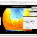
Panoply for Mac is an utility that enable user to plot raster image. Depending on the data, it can draw global longitude-latitude images or pole-to-pole latitude-vertical images.Panoply is a cross-platform application which plots geo-gridded arrays from netCDF, HDF and GRIB datasets. The utility can also combine two arrays and can project the analysis using more than 100 maps. ...

Author Robert B. Schmunk
Released 2024-03-01
Filesize 36.40 MB
Downloads 470
OS Mac OS X
Installation Instal And Uninstall
Keywords plot raster image, longitude image, pole-to-pole image, raster image, rasterize, raster
Users' rating
(24 rating)
Panoply for MacCADMac OS X
Panoply for Mac - map viewer Freeware Download Notice

Panoply for Mac Free Download - we do not host any Panoply for Mac torrent files or links of Panoply for Mac on rapidshare.com, depositfiles.com, megaupload.com etc. All Panoply for Mac download links are direct Panoply for Mac download from publisher site or their selected mirrors.

Panoply for Mac freeware - The Latest User Reviews
Panoply for Mac freeware - The Latest Versions History
5.3.3 Mar 1, 2024 New Release
5.3.2 Jan 31, 2024 New Release
5.3.1 Jan 2, 2024 New Release

Most popular CAD freeware downloads

Panoply for Mac

5.3.3 freeware download

... one plot by differencing, summing or averaging. Create map plots of trajectory data based on the CF ... Plot lon-lat data on a global or regional map using any of over 200 map projections or ...

QGIS for Mac

3.34.4 freeware download

... database formats and lets you browse and create map data on your computer. QGIS supports many ... initial goal was to provide a GIS data viewer. QGIS has reached that point in its evolution ...

Panoply

5.3.3 freeware download

... Plot lon-lat data on a global or regional map (using any of over 75 map projections) or make a zonal average lineplot. * ... PDF or PostScript graphics files. * Export lon-lat map plots in KMZ format. ...

QGIS

3.34.4 freeware download

... database formats and lets you browse and create map data on your computer. QGIS supports many ... initial goal was to provide a GIS data viewer. QGIS has reached that point in its evolution ...

QGIS for Linux

3.34.4 freeware download

... database formats and lets you browse and create map data on your computer. QGIS supports many ... initial goal was to provide a GIS data viewer. QGIS has reached that point in its evolution ...

CARIS Easy View

4.2.13 freeware download

... View your spatial data using the free CARIS viewer. CARIS Easy View allows users to view spatial ... It is important for a geographical data viewer to offer support for multiple types of files, ...

Thuban for Windows

1.2.2 freeware download

Thuban is an interactive geographic data viewer (GIS viewer) which features methods to visualize, explore, and analyze ... information. Thuban is an Interactive Geographic Data Viewer with the following features: # Vector Data ...

Thuban for Mac OS X

1.0.1-3 freeware download

Thuban is an interactive geographic data viewer (GIS viewer) which features methods to visualize, explore, and analyze ... information. Thuban is an Interactive Geographic Data Viewer with the following features: # Vector Data ...

Thuban for Linux

1.2.2 freeware download

Thuban is an interactive geographic data viewer (GIS viewer) which features methods to visualize, explore, and analyze ... information. Thuban is an Interactive Geographic Data Viewer with the following features: # Vector Data ...

QFitsView

3.1 Revision 74 freeware download

... files. The user can change the color map and the scale user for rendering the image in order to emphasize certain elements. ...