Open Visual Trace Route 1.7.1 freeware

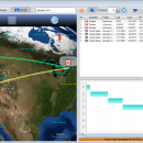
... can use this accessible and easy-to-use application to view the shortest route between where you are and where you want to go. ...

Author Leo Lewis
Released 2018-07-29
Filesize 37.90 MB
Downloads 563
OS Windows XP, Windows Vista, Windows Vista x64, Windows 7, Windows 7 x64, Windows 8, Windows 8 x64, Windows 10, Windows 10 x64
Installation Instal And Uninstall
Keywords view map, map explorer, map navigator, map, navigator, explore
Users' rating
(10 rating)
Open Visual Trace RouteCADWindows XP, Windows Vista, Windows Vista x64, Windows 7, Windows 7 x64, Windows 8, Windows 8 x64, Windows 10, Windows 10 x64
Open Visual Trace Route - view data Freeware Download Notice

Open Visual Trace Route Free Download - we do not host any Open Visual Trace Route torrent files or links of Open Visual Trace Route on rapidshare.com, depositfiles.com, megaupload.com etc. All Open Visual Trace Route download links are direct Open Visual Trace Route download from publisher site or their selected mirrors.

Open Visual Trace Route freeware - The Latest User Reviews
Open Visual Trace Route freeware - The Latest Versions History
1.7.1 Jul 29, 2018 New Release - Library: Upgrade to geoip v2
- Feature: DNS loc records feature
- Feature: Use system proxy when available, allow to specify user and password
- Feature: Anti-aliasing fonts
- Library: Upgrade world wind version
- Library: Upgrade required Java version to 1.8
- Fix : Fix hanging network interface detection
- Fix : Increase geoip db download timeout to avoid issue on first startup
1.3.0 Beta Jun 28, 2013 New Release · Upgrade to Worldwind 1.5.0, change layer panel, add graticule
· Add Gantt view of the route
· Add Replay function of the traceroute
· Implement bi-directional selection synchronization maptable
· Focus on the last point of the route during tracing
· Update visual of the Route (3d shape)
· Update labels of the points (cities) of the route
· Save application window size and split location when exiting the application
· Highlight current route point during tracing (both map and table)
· Fix an error when clearing selection the table
· Fix an error that crashed the application when starting from a directory that has space characters inside its path
· Fix a memory leak when tracing the route
1.2.1 Beta Jun 20, 2013 New Release · Remove the Applet version (JNLP files than contains JOGL native libs are no longer maintained by Oracle/JOGL)
· Refactor installer, remove the local dir, simplify native library management
· Better error management

Most popular CAD freeware downloads

Panoply for Mac

5.4.3 freeware download

... plots geo-gridded arrays from netCDF, HDF and GRIB datasets. Panoply is designed to help you view and process the data included in netCDF, HDF, GRIB, and other types ...

p3d

2.6.2 freeware download

p3d is a general data-reduction tool that is intended to be used with data of fiber-fed integral field spectrographs (IFSs). This tool ... useful for people who have access to astronomical data of such an instrument. Data-reduction tasks, which are ...

FilterPro Desktop

3.1.0.23446 freeware download

... as ability to adjust passive element tolerances and view response variations; scale passive component values; and view and export filter performance data to Excel. FilterPro active filter design ...

SolidFace 3D CAD PTV

24.0.0.X freeware download

... multi-part modeling and in-context editing. Import existing CAD data and use SolidFace to collaborate with a vendor. Import existing CAD data and using standard X_T, X_B, DWG, DXF, BMP ...

TNTmips for Mac OS X

20240111 freeware download

... you work with virtually any type of geospatial data including imagery, terrain surfaces, and map data with associated database attributes. It provides all the tools you need ...

MITO

2.0 freeware download

... MITO provides interaction techniques for manipulating 3D medical data in a virtual environment by 2 DOF input devices. FEATURES: · DICOM compliant · ...

Elshayal Smart

23.02 freeware download

... Earth, and Trace & save GPS route and View and Rectify Raster Images gif, jpg, bmp and ... remove layers, swap layers, save layer, set layer data source, layer properties, zoom in & zoom out, ...

TNTmips

20240404 freeware download

... you work with virtually any type of geospatial data including imagery, terrain surfaces, and map data with associated database attributes. It provides all the tools you need ...

NetLogo

6.0.4 freeware download

... or multiple variables, which you can adjust to view the results. For instance, climate change hinges on ... and controlling agents Export and import functions (export data, save and restore state of model, make a ...

QGIS for Linux

3.36.1 freeware download

... Software (FOSS). QGIS supports vector, raster, and database formats and lets you browse and create map data on your computer. QGIS supports many common ...