Navigation:
- Freeware
- - Graphic Apps
- - CAD
- - CueMol
CueMol 2.2.3.442 freeware
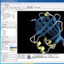
... format), MSMS surface data, and GRASP electrostatic potential map. ...
| Author | BKR Laboratory |
| Released | 2017-10-16 |
| Filesize | 44.80 MB |
| Downloads | 1439 |
| OS | Windows XP, Windows Vista, Windows Vista x64, Windows 7, Windows 7 x64, Windows 8, Windows 8 x64 |
| Installation | Instal And Uninstall |
| Keywords | view macromolecular structure, macromolecular structure visualization, visualize macromolecular structure, viewer, view, visualize |
| Users' rating (11 rating) |
CueMol Free Download - we do not host any CueMol torrent files or links of CueMol on rapidshare.com, depositfiles.com, megaupload.com etc. All CueMol download links are direct CueMol download from publisher site or their selected mirrors.
| 2.2.3.442 | Oct 16, 2017 | New Release | Edge lines now become (semi)transparent according to the color of the belonging triangle edges. This enables "segment end fadeout" display of the ribbon and cartoons with edge lines. Error in the "Mol Superpose" dialog of auto-recenter checkbox is fixed. |
| 2.2.3.422 | Oct 16, 2017 | New Release | BUGFIX: Crashes when creating symmetry-related molecule |
| 2.2.3.421 | Aug 17, 2017 | New Release | "show unit-cell" button was added in the density panel. Now coordinates files are fetched from RCSB web site in the mmCIF format that supports large molecules. Internal representation unit of the time value was changed from milli-second to nano-second to increase the animation precision. You can now specify start/end cap properties separately in the atomintr renderer settings. (documents??) |


