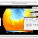
Panoply for Mac 5.4.3 freeware

Panoply for Mac is an utility that enable user to plot raster image. Depending on the data, it can draw global longitude-latitude images or pole-to-pole latitude-vertical images.Panoply is a cross-platform application which plots geo-gridded arrays from netCDF, HDF and GRIB datasets. The utility can also combine two arrays and can project the analysis using more than 100 maps. ...

Author Robert B. Schmunk
Released 2024-06-24
Filesize 36.40 MB
Downloads 1068
OS Mac OS X
Installation Instal And Uninstall
Keywords plot raster image, longitude image, pole-to-pole image, raster image, rasterize, raster
Users' rating
(43 rating)
Panoply for MacCADMac OS X
Panoply for Mac - by Freeware Download Notice

Panoply for Mac Free Download - we do not host any Panoply for Mac torrent files or links of Panoply for Mac on rapidshare.com, depositfiles.com, megaupload.com etc. All Panoply for Mac download links are direct Panoply for Mac download from publisher site or their selected mirrors.

Panoply for Mac freeware - The Latest User Reviews
Panoply for Mac freeware - The Latest Versions History
5.4.3 Jun 24, 2024 New Release
5.4.1 Jun 1, 2024 New Release
5.4.0 May 11, 2024 New Release

Most popular CAD freeware downloads

Panoply for Mac

5.4.3 freeware download

Panoply for Mac is a cross-platform application which plots geo-gridded arrays from netCDF, HDF and GRIB datasets. Panoply is designed to help you view and process ...

ShareCAD

2.0 freeware download

ShareCAD is a free online service developed by CADSoftTools. With its help users can view drawings in web browsers on the following platforms: Windows, OS X, ...

p3d

2.6.2 freeware download

p3d is a general data-reduction tool that is intended to be used with data of fiber-fed integral field spectrographs (IFSs). This tool can be useful for ...

JMARS

3.1.5 freeware download

JMARS is an acronym that stands for Java Mission-planning and Analysis for Remote Sensing. It is a geospatial information system (GIS) developed by ASU's Mars Space ...

5 freeware award

FilterPro Desktop

3.1.0.23446 freeware download

FilterPro v3.1 active filter design software offers a new and improved user interface and a more accurate and robust active filter design engine, thanks to updates, ...

JMARS for Windows

3.1.5 freeware download

JMARS is an acronym that stands for Java Mission-planning and Analysis for Remote Sensing. It is a geospatial information system (GIS) developed by ASU's Mars Space ...

FreeDiams for Mac OS X

1.0.0 freeware download

FreeDiams prescriber is the result of FreeMedForms prescriber plugins built into a standalone application. FreeDiams is a multi-platform (MacOS, Linux, FreeBSD, Windows), free and open source ...

Sundi

1.070 freeware download

In the summer 2003 I discovered the world of sundials and quick found that the community of sundial maker is the next great community after the ...

MyCadbox

1.0.0.0 freeware download

MyCadbox highlights: * Open large STEP and IGES files ultra-fast on PC and iPad * Share STEP and IGES files easily with your team * Sync ...

TNTmips for Mac OS X

20240111 freeware download

TNTmips for Mac is a complete Geographic Information System (GIS) that lets you work with virtually any type of geospatial data including imagery, terrain surfaces, and ...